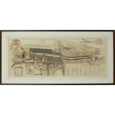
Lot 115

Gordon, James, of Rothiemay (1617-1686)
Civitatis regiae, antiquissime et nobilissime Edinodunensis tabulam
Rare Books, Manuscripts, Maps & Photographs
Auction: 07 February 2024 from 10:00 GMT
Description
[Probably Amsterdam: F. de Wit, c.1690]. Bird's-eye view of Edinburgh from the south incorporating royal arms of Scotland top left, dedication to provost of Edinburgh Archibald Tod within decorative cartouche lower left, and large panel containing key to street and place names lower right, hand-coloured engraving on two sheets, mounted, framed and glazed, mount aperture 42.5 x 108cm [Cowan/Watson, Maps of Edinburgh 4a]
Footnote
The first properly cartographic printed view of Edinburgh, preceded only by the highly stylised depiction of the city in Braun and Hogenberg's Civitates orbis terrarum, published in the late 16th century and bearing little relation to the actual layout of the city except for the castle. Together with his father, Robert Gordon of Straloch, James Gordon drew up the maps of Scotland used by Johannes Blaeu in the Scottish and Irish volume of his Theatrum Orbis Terrarum, which appeared in 1654. In 1647 he was employed by Edinburgh town council to draw up a plan of the city, being rewarded with 500 merks and election as a burgess and guild brother for his efforts. Jeffrey C. Stone in ODNB states that ‘the plan was engraved and published in a rare first edition by Blaeu about 1650 and then by De Wit about 1695’. Cowan's Maps of Edinburgh does not cite a Blaeu edition; the present copy, however, lacks the imprint ‘F. de Wit Excudit Amstelodami’ next to the dedication cartouche mentioned in Cowan's description. There was an engraved facsimile published by R. Kirkwood in 1817, but this can be identified by its misnumbering of Tinnis Court as 51 instead of 31 in the key, and in any case contains a new title in the lower margin, not present here.