Lot 113

Blaeu, Johannes
[Tooneel des Aerdrycx, oft Nieuwe Atlas … Vyfde Deel]


Rare Books, Manuscripts, Maps & Photographs
Auction: 07 February 2024 from 10:00 GMT
Description
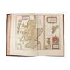
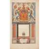
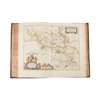
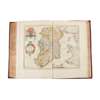
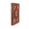
[i.e. the Scotland and Ireland volume from the Theatrum Orbis Terrarum, Dutch edition]. [Amsterdam: Johannes Blaeu, 1654]. Folio (50 x 33cm), contemporary morocco, spine gilt in compartments, gilt panels incorporating arabesque cornerpieces and central lozenges to sides, all edges gilt, [8] 189 [1] 70 [2] pp., engraved hand-coloured architectonic title-page incorporating arms of Scotland (central panel blank, i.e. without printed slip containing title, but with onlaid photographic roundel of the arms of clan MacKay), 55 engraved maps with contemporary hand-colouring, all but one double-page, comprising ‘Insulae Albion et Hibernia’ (Ptolemaic map of the British Isles), ‘Scotia antiqua’, ‘Scotia Regnum’, ‘Hibernia Regnum’, and the Scottish and Irish counties, islands and regions, front joint rubbed, front inner hinge discreetly strengthened, a little light toning, Strathnaver map coat of arms embellished with later onlays containing the arms and motto of the clan MacKay, pp. 133-6 with tide mark in upper margin (not affecting any maps) [Chubb, ‘Atlases of Scotland’, II; Skelton 59]
Footnote
An excellent copy of the first printed atlas of Scotland' (Skelton), being the fifth volume of Blaeu's 1654 world atlas, this copy from the Dutch-text edition: editions with text in Latin, Dutch, French and German were all published in the same year, with a Spanish edition appearing in 1659; the maps themselves are titled in Latin and English. The work contains 'three general maps and forty-six maps of Scottish counties and regions, engraved at Amsterdam from drawings by Robert Gordon of Straloch (1580-1661) and his son James (c.1615-1686), minister of Rothiemay in Banffshire, together with a general map of Ireland and five maps of Irish provinces, after Mercator and Jansson. The maps by the Gordons incorporate the results of the earliest topographical survey of Scotland, that made by Timothy Pont at undetermined dates, apparently within the last two decades of the 16th and the first decade of the 17th century' (ibid.).