Lot 263

Flinders, Matthew

Auction: 13 January 2010 at 11:00 GMT
Description
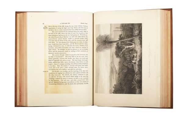
A voyage to Terra Australis; undertaken for the purpose of completing the discovery of that vast country, and prosecuted in the years 1801, 1802, and 1803, in His Majesty's ship The Investigator. London: G. and W. Nicol, 1814 [charts dated 1814-1829] . 3 volumes including atlas folio. 2 volumes, 4to, [ii], ix, [x], cciv, 269; [ii], 613], text volumes with 9 engraved plates after William Westall, atlas folio [663 x 475mm.] with 16 engraved charts [9 double-page], 2 double-page coastal profiles, and 10 engraved botanical plates after Ferdinand Bauer, text nineteenth century calf, atlas nineteenth century half calf with marbled boards, Northern Light Board gilt stamp at head of spines, text lacking half titles, with plates offset onto text, some spotting, joints cracked, head and tail of spine of volume 1 rubbed and scrape to lower board, atlas with 5cm. tear to chart no 1 repaired, offsetting to some double-page charts and coastal profiles, atlas worn, scraped and joints with short split at base (3)
Footnote
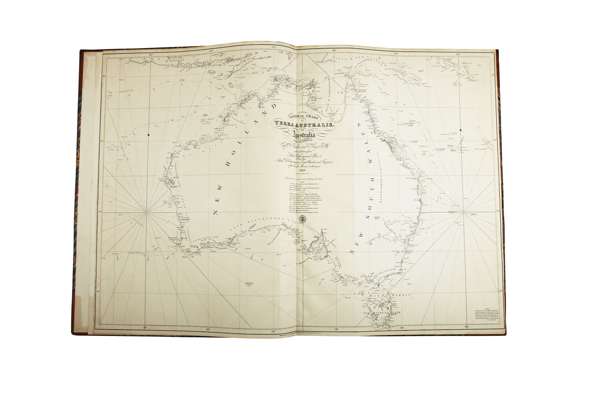
Note: Flinders's voyage to explore the entire coastline of Australia represented the first circumnavigation of the continent. 'Such is the historical importance of this monumental work that no general collection of Australian books could be considered complete without it' (Wantrup). By 1822 several of the charts published in 1814 were obsolete so they were revised, and the whole atlas was reissued by the Hydographical Office of the Admiralty. Some plates were issued with the statement "Corrected to 1822" and the remaining plates, including the coastal profiles and botanical illustrations were issued with the revised imprint and the Hydrographical Office seal, and, in the case of the charts, with compass roses and rhumb-lines. The complete atlas was not again issued by the Hydographical Office, but as time passed individual plates were revised and reprinted, reprinted without revision, or withdrawn as necessary. In the present copy 8 charts are later issues of the maps, published by the Hydographical Office to the Admiralty rather than by G. & W. Nicol, and all 8 are watermarked "J. Whatman Turkey Mills 1834". These 8 charts comprise:
Chart no. 1 [General chart of Terra Australis, or Australia from the surveys of Capt. Flinders and King, with additions from Lieut. Jeffreys and Roe, also from Adml. D'Entrecasteaux, Capt. Baudin and Freycinet of the French marine to the year 1829. Published by Capt. Hurd R.N., Hydrographer to the Admiralty, Jan. 1st 1814 to 1829]
Chart no. 6 [South Coast Sheet V], published by Capt. Hurd, Hydrographer to the Admiralty, and dated Feb. 1st 1814 [Tooley 594]
Chart no. 10 [East Coast Sheet III], marked "Additions to 1826, by Captain Philip P. King", and published by Capt. Hurd, Hydrographer to the Admiralty, Jan. 1st 1814/1826 [not in Tooley]
Chart no. 11 [Chart of part of the NE Coast of Australia by Philip P. King, Commander, R.N., 1819, 20, 21. Sheet 1], published at the Hydrographical Office, 10th November 1824 [Tooley 801]
Chart no. 12 [Chart of Part of the NE Coast of Australia by Philip P. King, Commander, R.N., 1819, 20, 21. Sheet 3], published at the Hydrographical Office, 17th November 1824, [Tooley 801];
Chart no. 14 [North coast, sheet II], 15 [NW side of the Gulf of Carpentaria] and the two coastal profiles [16 & 17], published by Capt. Hurd, Hydrographer to the Admiralty, 1st June 1814 [Tooley 599].
The naturalist Robert Brown and the renowned natural history painter Ferdinand Bauer accompanied the voyage: Brown supplying the 'General remarks on the botany of Terra Australis' and Bauer the ten botanical plates in the Atlas. In this copy the ten botanical plates are on slightly smaller and thinner paper than the charts and are not watermarked. Ferguson 576; Perry & Prescott, p.164-165.