Lot 197
SAYER R. & BENNET J.
Auction: 1 February 2005 at 11:00 GMT
Description
The American military pocket atlas; being an approved collection of correct maps, both general and particular of the British Colonies; especially those which now are, or probably may be the theatre of war ... 1st edition, 6 fldg. maps, hand coloured in outline, mounted on guards, original half calf, marbled boards, rubbed, worn and lacking corner pieces, maps with some small tears and splits at folds, 8vo., London, [1776]
Note: Harley, Petchenick & Towner Mapping the American revolutionary war pp. 96ff; Nebenzahl Atlas of the American Revolution pp. 11-17; Nebenzahl A bibliography of printed battle plans of the American Revolution; Sabin 1147; Sellers & Van Ee Maps and charts of North America and the West Indies
known as a "holster" atlas, it was deliberately designed to be of special use for mounted officers in the American Revolutionary war, the publishers describing it as " a portable Atlas of North America calculated in its Bulk and Price to suit the Pockets of Officers of all Ranks." (Advertisement at the front) This miliatry Baedeker was availble for purchase both in London and New York. It covers North America as a whole, the West Indies, the Northern Colonies, the Middle Colonies, the Southern Colonies and Lake Chaplin. Such maps were also useful for those at home some three thousand miles away from the theatre of war, indeed pictorial news about the war was almost entirely limited to maps.
In fact, many of the maps were over twenty years out of date and were in the most part compilations of the workshop rather than engravings from original surveys. Scales vary from no scale at all to 30 miles per inch, "but to a greater or lesser extent none of the printed maps of the Revolutionary period was adequate for all the military uses to which the combatants sough to use them." (Hareley et al.)
Provenace: With the contemporary signature of John Hamilton of Sundrum Castle on the titlepage and subsequently from the library of Pallinsburn House, Northumberland
Contents
1. North America, as divided amongst the European powers. By Samuel Dunn. 1774. Shows borders, towns and cities, Indian tribal territory and relief. With the figure "39" (the 9 trimmed) in the upper margin. 32 x 45 cms. Annotated "1" on the verso. Sellers & Van Ee 131
2. A compleat map of the West Indies… By Samuel Dunn. 1774. Covers the South U.S., eastern Mexico, north South America, and the West Indies. Shows a few towns, rivers, routes of navigation and relief. With the figure "41" in the lower margin. 32 x 47 cms. Annotated "2" on the verso. Seller & Van Ee 1697
3. A general map of the Northern British Colonies … from the maps published by the Admiralty and the Board of Trade, regulated by the astronomic and trigonometric observations of Major Holland and corrected from Governor Pownall's late map 1776. 1776. Covers the area from James Bay to Delawar Bay and from the Atlantic coast to the West end of Lake Ontario. Shows towns, cities, Indian tribal territory, some roads, trails, forts, etc. Annotated "3" on the verso. 50 x 67 cms. Nebenzahl. Bibliography no. 41; Sellers & Van Ee 143
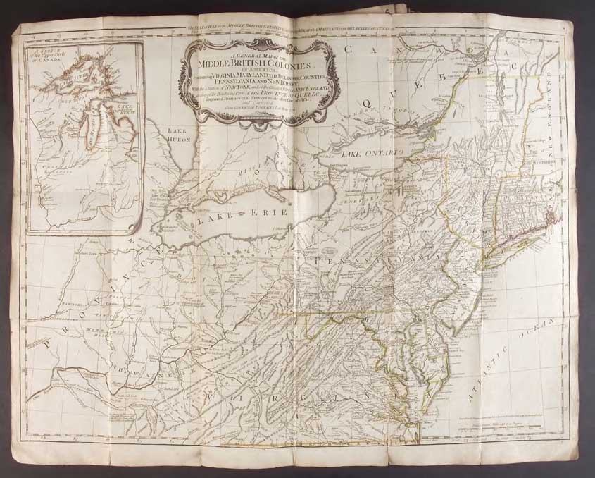
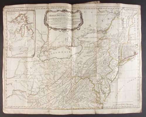
4. A general map of the Middle British Colonies … improved from several surveys made after the late war, and corrected from Governor Pownall's late map 1776. 1776. A reissue of Thomas Kitchin's pirated edition of Lewis Evan's map with additional information, many names of newly revealed forts, etc. Evan's map was one of the landmarks of American cartography and appeared in at least 16 pirated editions. The present map has insert entitled " A sketch of the upper parts of Canada" and focuses on the "Illinois Country" (with Fort Detroit shown) where Colonel Hay Hamilton unsuccessfully attempted to hold the furthest Western frontier region against George Rogers Clark and his small force of Virginia militia men. The considerable detail of the map as a whole enables the viewer to follow most of the campaign of the war, except in New England, Quebec and the deep South. 49 x 67 cms. Annotated "4" on the verso. Sellers & Van Ee 714 7th state.
5. A general map of the Southern British Colonies … from the modern surveys of Engineerde Brahm, Capt. Collet, Mouzon & others; and from the large hydrographical surveys of the coasts of East and West Florida by B. Romans. 1776. Shows state and provinicial borders, towns and cities, precincts in South Carolina, forts, roads, etc. Indian villages and tribal territory. Annotated "5" on the verso. 53 x 67 cms. Sellers & Van Ee 396
6. A survey of Lake Champlain. Including Lake St. George, Crown Point and St. John. Surveyed … by William Brassier 1762. 1776. Shown are the Skenesborough patent, forts and the road from Fort Anne to South Bay, the road to Crown Point, sawmills, some vegetation and relief. The naval engagements at Valcour Bay and Buttonmold Bay in Oct. 1776 between Sir Guy Carleton and Benedict Arnold have been added to the map. An insert shows "A particular plan of Lake George. Surveyed in 1756 by Capt. Jackson. 68 x 50 cms. Annotated "6" on the verso. Nebenzahl. Bibliography no 46; Sellers & Van Ee 1073